The City of Syracuse actively manages the floodplains within city limits. Most streams within Syracuse, including Onondaga Lake have flooded in recent years with associated property damage. The City manages the regulated floodplain in order to reduce risks to residents, homes, property and commercial businesses. This includes regulation of new construction and development, and substantial improvements to structures.
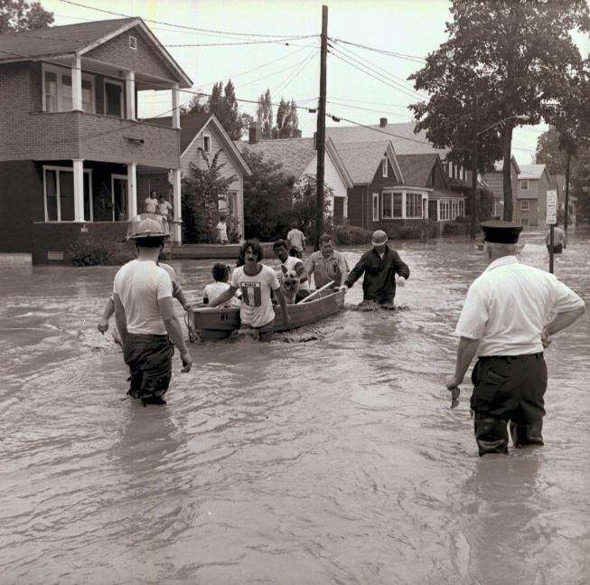
" July 1974 Flooding on Sterling Street. Residents were evacuated from several blocks as flood water reached 1,000 feet from Onondaga creek into the neighborhood."
For Information on Flood Insurance go to FEMA's FloodSmart website:
https://www.floodsmart.gov/
Syracuse Floodplain Maps
Is My House or Building in the Floodplain?
In the early 2000’s, the Federal Emergency Management Agency (FEMA) restudied the flood risks for Syracuse streams and provided revised flood maps to Syracuse for review. After successful technical appeals by Syracuse to reduce the flood zones, FEMA finalized the maps in 2016, and the Syracuse Common Council adopted the new flood maps in November 2016. If the City did not adopt the maps, Syracuse risked losing membership in the National Flood Insurance Program and losing federally subsidized flood insurance for residents. It also would have risked Syracuse’s eligibility for federal aid after flood-related disasters.
General Syracuse Floodplain [Map(PDF, 902KB)]
FEMA Flood Insurance Rate Maps (FIRMs) – For detailed mapping showing floodzones for the regulated streams within Syracuse, click the appropriate stream:
Click here for Harbor Brook Flood Maps
Click here for Ley Creek Flood Maps
Click here for Meadowbrook Flood Maps
Click here for Onondaga Creek Flood Maps
Click here for Onondaga Lake Flood Maps
Flood Maps On-Line:
Onondaga County Web GIS: https://spatial.vhb.com/onondaga/
FEMA Map Service Center: https://msc.fema.gov/portal/home
Paper Copies of the FEMA floodzone maps can be found at:
- Syracuse Department of Engineering Room 401 City Hall; 8:30 A.M. to 4:30 P.M. weekdays (telephone 315-448-8200).
- Onondaga County Central Library Main Branch (at Galleries of Syracuse - 447 S. Salina Street)
What if I think I am outside of the Flood zone, but My Bank Requires Flood Insurance?
FEMA has established procedures to change your property’s status if you think your property or structure is incorrectly included in the Special Flood Hazard Area (100-Year Flood zone). These processes are called the Letter of Map Amendment or LOMA and the Letter of Map Revision Based on Fill, or LOMR-F. Through these processes, an individual who owns, rents, or leases property may submit certain mapping and survey information to FEMA and request that FEMA issue a document that officially removes a property and/or structure from the SFHA. In most cases, the applicant will need to hire, at their own expense, a Licensed Land Surveyor or Professional Engineer to prepare an Elevation Certificate for the property. Depending on the type of application submitted, the City may also need to sign a Community Acknowledgement Form to accompany the application.
For a list of available Elevation Certificates in Syracuse, click the link. If on the list, contact the Engineers Department for a copy of the Elevation Certificates.
Syracuse-Elevation-Certificate-List_1.pdf(PDF, 35KB)
Need help? Contact the Syracuse Engineering Department at 315-448-8200 or rhouck@syrgov.net
Who is Required to Have Flood Insurance?
Before someone can get a loan from a federally-banked lender (most banks fall in this category), the lender will determine if the building is in the Special Flood Hazard Area (SFHA) also called the “100-Year Floodzone”. If the structure is in the SFHA, flood insurance will be required. Flood insurance rates are determined based on the age and type of construction of the house or building, the base flood elevation (BFE) of the nearby stream, and the flood zone in which your building is located. If an owner fully owns their home (no mortgage), it is the choice of the owner whether to purchase flood insurance.
IMPORTANT NOTE Homeowners insurance does not usually cover flooding. If you are in a floodplain, protect your home with flood insurance! Flood insurance policies have varying coverage and flood insurance is also available for contents, renters, and properties outside of the SFHA. Check with your insurance agent about the coverage that is best for you.
FEMA-WHY-DO-I-NEED-FLOOD-INSURANCE.pdf(PDF, 3MB)
For Information on Flood Insurance go to FEMA's FloodSmart website: https://www.floodsmart.gov/
Flood Insurance Discount of 15% to City Residents
The City of Syracuse participates in the National Flood Insurance Program (NFIP) Community Rating System (CRS). This system rewards Syracuse for actively promoting sound floodplain management and working to reduce flood risks. The City’s CRS rating was recertified in 2021 and our rating provides a flood insurance discount of 15 percent for City homeowners. Confirm with your insurance agent that you are receiving this discount!
Flood Insurance Property Tax Exemption
In 2019, the New York State legislature passed a law sponsored by Assemblywoman Pamela Hunter that authorized a special property tax exemption for households within Syracuse that are required to purchase flood insurance. This exemption could result in up to approximately $750 in reduced City taxes.
In order to qualify for the tax exemption, the property must be:
- Located within the Special Flood Hazard Area
- A 1 to 3 family residential property
- Insured through a federally-backed flood insurance policy for the current tax year
- Have no delinquent City taxes; and
- Either be located in the City’s Neighborhood Revitalization Strategy Area (NRSA) or, if located outside of the NRSA, be owner-occupied with a total household income of less than $62,985 per year
Application forms are available below and at the City Assessment Office (City Hall, First Floor Room 130, 233 E. Washington Street). For this credit, an applicant must apply each year prior to January 1 to the Syracuse Assessment Department for the exemption in the following year. The City Assessment Dept. also sends an informational letter yearly to all property owners within the qualifying areas.
Flood Insurance Property Tax Exemption Information Sheet(PDF, 187KB)
Flood Insurance Property Tax Exemption Form(PDF, 88KB)
Onondaga Creek, Harbor Brook, Ley Creek, Meadowbrook, and Onondaga Lake all have reached flood levels in the recent years, causing property damage. To reduce flooding risks in Syracuse, a number of projects have been implemented. From approximately 1900 through 1960, the Onondaga Creek channel within Syracuse was straightened, enlarged, and hardened to move potential flood waters, as well as combined sewer overflows, more rapidly through the City. The Onondaga Dam was constructed in 1950 and reduces Onondaga Creek flood risks for the Onondaga Nation, the Town of Onondaga and the City of Syracuse. For Harbor Brook, the Grand Avenue/Velasko Road detention basin reduces flood risk for up to the 25-year flood event. Likewise, the County detention basin adjacent to Barry Park reduces flood risk for Meadowbrook for up to the 5-year flood event. Even with these measures, flooding remains a real threat for properties near these streams. In addition, flood risks have increased for Onondaga Creek within Syracuse as sediment from upstream areas continues to accumulate in the creek channel reducing the channel flow capacity.
Flash Floods
Syracuse and Onondaga County experience flash flooding every year where stream levels rise rapidly due to intense rainfall. Intense rainfall will also cause storm sewer back-ups and flash flooding onto local roads. To reduce flood risks, Syracuse cleans and monitors creek channels and overbanks, and cleans out over 9,000 catch basins annually to prevent sewer back-ups. It is a violation of city law to dispose of any solid waste (trees, garbage, concrete, etc.) in any creek or channel throughout the city. Alert the City DPW at 315-448-CITY (448-2489) to debris and tree blockages within stream channels.
Flood Preparation & Safety(PDF, 9MB)
Water Levels on Onondaga Creek (USGS Dorwin Ave Gage) https://waterdata.usgs.gov/monitoring-location/USGS-04239000/#dataTypeId=continuous-00065-0&period=P7D
Water Levels on Onondaga Creek (USGS Spencer St. Gage) https://waterdata.usgs.gov/monitoring-location/USGS-04240010/#dataTypeId=continuous-00065-0&period=P7D
Water Levels on Onondaga Lake (SGS)
https://waterdata.usgs.gov/monitoring-location/USGS-04240495/#dataTypeId=continuous-62614-0&period=P7D&showMedian=true
Meadowbrook Repetitive Loss Area
FEMA determined that portions of the Meadowbrook floodplain in the Scottholm area are within a repetitive loss area due to recurring flood damages and flood insurance claims. The City notifies the property owners within this repetitive loss area yearly by mail of the flood risks and available NFIP flood insurance.
Hazard Mitigation Plan
Syracuse is helping revise the Draft 2025 Onondaga County Multi-Jurisdictional Hazard Mitigation Plan (HMP). This plan identifies initiatives to locally reduce risks for all forms of hazards including flooding. This plan helps Syracuse to coordinate with the New York State Emergency Management Office and FEMA, and provides opportunities for hazard mitigation funding from state and federal sources.
To view the HMP, please use this link to the Onondaga County Planning website:
http://www.ongov.net/planning/
Onondaga Creek Flood Reduction Studies
Syracuse has been working with the NYSDEC, the US Army Corps of Engineers and FEMA to reduce Onondaga Creek flood risk. In June 2016, the NYSDEC completed a study of Onondaga Creek which analyzed flood risk reduction measures including sediment and vegetation removal, channel modifications, removal of abandoned low-clearance bridges, and modifications to the Onondaga Dam. The sediment removal, channel alteration, and dam modification alternatives are considered by the City to have low feasibility due to high cost and potential adverse environmental and neighborhood impacts. The City is actively thinning vegetation along Onondaga Creek as part of riparian management.
Arsenal Park Flood Study
In 2025 Syracuse completed an engineering study to assess if open space lands at Dorwin Avenue next to Onondaga Creek (called the Arsenal Park tract) could be modified to store high flows on Onondaga Creek. The goal of this project would be to reduce flood elevations and flood extents in downstream residential areas near Midland and Bellevue Avenues. The study found that this tract of land could provide enough storage to shrink the downstream flood extents enough to remove 50 homes from the floodplain out of 280 homes total in the floodplain. However, the costs for the project were very high (in the range of $20 to $40 million dollars) and had a Benefit to Cost Ratio (BCR) of less than 1.0. A BCR of 1.0 or greater is generally needed to seek state and federal funding for this type of flood mitigation project. The city is assessing ways to reduce the project costs to raise the BCR above 1.0 and also looking for additional food storage areas along Onondaga Creek.
Syracuse regulates new construction, site development and building renovation within the floodplain. In September 2016, the City adopted a new floodplain protection ordinance to reduce flood risk for new and improved structures, and to ensure that new floodplain development will not raise flood elevations, adversely affecting neighboring properties.
Syracuse Local Floodplain Protection Law(PDF, 2MB)
Requirements for New and Substantially Improved Buildings within the Floodplain
Residential structures - For new construction or substantial improvement in the SFHA, residential structures shall have the lowest floor, including basement or cellar, elevated to or above base flood elevation plus 2 feet freeboard. Wet-floodproofing of parking and storage space (but not basements) is allowed.
Commercial, industrial or other non-residential structures - These types of new or substantially-improved buildings shall have the lowest floor elevated to or above base flood elevation plus 2 feet freeboard, or must be dry-floodproofed so that the structure is watertight below the base flood level plus freeboard, with walls substantially impermeable to the passage of water.
Requirements in the SFHA and Floodway
Maintain Flood Storage – The volume of project fill cannot exceed the volume of excavation within the floodplain.
No Rise in Base Flood Elevation - Projects in the floodway are required to have an engineering analysis to demonstrate no rise in flood elevations caused by the project. For projects in the SFHA, an engineering analysis may be required to demonstrate no rise in flood elevations would result from the development.
Specific city and state building codes also apply to new and substantially improved structures in the SFHA. New construction, alteration or addition to your building, or grading or filling of the site will require all applicable building permits and a Floodplain Development Permit.
Floodplain Development Permit Application(PDF, 98KB)
NEED MORE HELP? Contact the Department of Engineering (315-448-8200) or the Department of Neighborhood & Business Development, Division of Code Enforcement (315-448-8600) regarding any construction or development within the regulated floodplain